Brunswick Engineering Creates a New Truck Mounted Road Mapper with FLIR A65 and FLIR Ladybug5+ 360° Spherical Imaging Camera
Maintaining roads and bridges is a never-ending task for civil engineers. Roads, bridges, and highways are constantly under stress from countless numbers of travelers and the never-ending exposure to weather. Repairs require blocking lanes or entire roads, slowing down traffic and upsetting drivers while adding costs to city budgets. With these stresses in mind, an engineering firm from New Brunswick, Canada developed a solution for finding impending road hazards early so they can be fixed with little disruption.
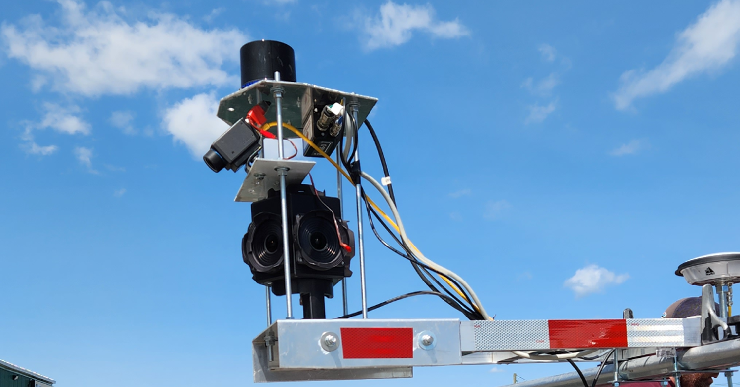
Brunswick Engineering is a consulting firm that provides a wide array of solutions for civil services to its clients. The firm has been experimenting with mounting an array of sensors to their trucks to create an efficient, mobile solution to the problem of inspecting miles of concrete. Stephen Perry, civil engineer and President and CEO of Brunswick engineering, told us about his firm’s newest build, which includes a FLIR A65 fixed-mount thermal imaging camera and FLIR Ladybug5+ 360° spherical camera.

Inspecting bridge decks and roads is one of Brunswick Engineering’s main lines of business. This often means using a Ground Penetrating Radar (GPR) which emits pulses of electromagnetic energy into the subsurface to detect differences and allows them to assess the health of concrete. However, this data isn’t very easy to digest for those who aren’t familiar with it. “If you’ve ever seen a radiogram from GPR, it looks like a broken fish finder,” says Perry. “We’re trying to associate that information with something easier for people to distinguish.”
Engineers are often looking for concrete delamination: the separation of concrete into different layers that is a sure sign of degrading infrastructure. If Brunswick Engineering’s crews find signs of delamination during their inspections, they provide the data to their clients—including a contour map to visualize where damage is forming—and make suggestions for repairs.
Perry says that while thermal imaging isn’t widely used within the civil engineering field, he began to see all the different applications after receiving his Thermographer Level 1 certification through the Infrared Training Center and through subsequent experimentation with the technology. The process of concrete delamination leads to air pockets under the surface that are easy to see with thermal imaging. That’s because air gaps act as a barrier that prevents heat from dissipating to the rest of the concrete and appear as hot spots on the surface. Brunswick Engineering discovered that mounting FLIR A65s on drones can be an efficient way to inspect bridge decks.
While traditional methods for concrete inspection get the job done, they cost a lot in time, money, and manpower. A traditional inspection might involve someone slowly scanning sections of road with a GPR while flaggers and pilons redirect traffic. Other methods also include “coring”, a practice where engineers cut cores out of the concrete and test slivers from it to see how much chloride is present to get an idea of the concrete’s health. If engineers wanted to core a road section every couple hundred meters, Perry estimates they would be on location for days as it takes roughly 10-15 minutes per core, and they must make sure they sufficiently cover their section with zig zagging patterns. With some of Brunswick’s clients having up to 90 bridges that need regular inspection, it’s easy to see how costs quickly add up.
With a clear need for faster inspections, Brunswick Engineering began experimenting with alternative solutions. Initially engineers mounted GPRs to their trucks to speed up inspection times, but soon started to wonder what else they could mount. Brunswick engineers added FLIR A65 thermal imaging cameras to their GPR mounts as the two technologies work well together to provide a more complete image. As Perry explained, “Let’s say we're on a bridge deck and we have an expansion joint in between two sections of the bridge. It’s usually steel which will show up very well in the thermal camera because it’s a different material than concrete and it shows up as a good reference point in the GPR data. It’s a very distinguished feature to be able to give some situational awareness of where we are on a bridge and how close are we to the edges or the next span.”

Brunswick engineers then figured if they had a GPR and thermal camera on their mount, they might as well have visuals as well. They originally tested having multiple traditional cameras on board, but soon switched to FLIR Ladybug5+ 360° spherical imaging camera. Having 360 degrees of visuals to go along with GPR and thermal data helps Brunswick document the topside of their inspection sites for their clients. To top it off, the engineering team also added a LIDAR sensor which allows them to create a 3D dense point cloud of the area being mapped which can then be brought into CAD to develop 3D models. All the mounted sensors are then connected to a Modbus which then feeds its data through an ethernet cable to an on-board laptop which can be accessed through a remote desktop.
“We’re just taking technology that’s been proven and mashing everything together in a way that hasn’t been done yet,” Perry told us. “We know individually all the different data sets work; we’re just getting them all matched together.”
By combining different data sets, Brunswick Engineering has made a huge leap in inspection times. Perry says their truck mounted sensors enable them to collect data travelling at 20 kilometers an hour without any issues. While crews using traditional methods could inspect about one bridge deck a day, Brunswick Engineering is able to inspect 20 bridges a day with their new solution. Not only is this a monumental decrease in inspection times, but they also avoid shutting down lanes: the team only requires a crash attenuator truck behind their inspection truck, eliminating the need for stationed traffic control.
Perry predicts Brunswick Engineering’s new system will only get better as time goes on, as a future goal of the project is to track historical trends as they gain more data. Being able to capture data more quickly and more easily means inspections could be performed more often. This would allow Brunswick Engineering to better compare how bridges in different locations facing different elements degrade over time. Additional data would also give maintenance teams a better idea of how to approach repairs and come up with more efficient maintenance plans.
By combining GPR, thermal, and visual data together, Brunswick Engineering has already made huge strides in their field in terms of inspection times and potential savings for their clients. While their new build is exciting, Perry says they’ll need to prove the capabilities of their work before gaining wider adoption. The civil engineer doesn’t seem too deterred though as he explained to us, “When we had the thermal cameras, people just didn’t understand what was being collected. We had to prove that we were more accurate than traditional means and this is the same thing. We have to prove that the technology is valid, and it can be used on these different projects. The more information we can get that verifies one technology to the other, the more it helps us to sell service.”
You can find more information on Brunswick Engineering by visiting their website.